TR = Tower-Roosevelt
Y-NE = Northeast Entrance
CV = Canyon Village
MAD = Madison Junction
FB = Fishing Bridge
Y-E = East Entrance
WT = West Thumb
MOR = Moran Junction
G-E = East Entrance
This is not an official government web site.
§1 Introduction. This report proposes a set of route numbers to be used on the roads of Yellowstone National Park. It extends smoothly to the John D. Rockefeller Jr Memorial Parkway and Grand Teton National Park.
The road system of Yellowstone is complicated enough that motorists, especially first-time visitors, might appreciate a clear and simple system of route numbering, particularly since a wrong turn can lead to many miles of wasted driving in this large park, whose area exceeds 3400 square miles. The fact that many intersections have auxiliary turn lanes, with some of the right turns channelized, suggests that there is enough traffic to justify installing route markers. On top of that, the Old Faithful area is served by a full-fledged interchange within the park.
With one isolated exception, there are currently no route numbers in Yellowstone. Major intersections do have guide signs with milages to features and to other intersections, but at present what is often the best way to identify a road is by saying that it connects such-and-such to such-and-such. For its part, Grand Teton does have a few route markers for the US routes passing through.
This proposal pertains merely to the installation of signs. It does not involve road construction, traffic lights, pavement markings, or street lights.
Useful source material:
All maps in this report are schematic, and hence are not to scale.
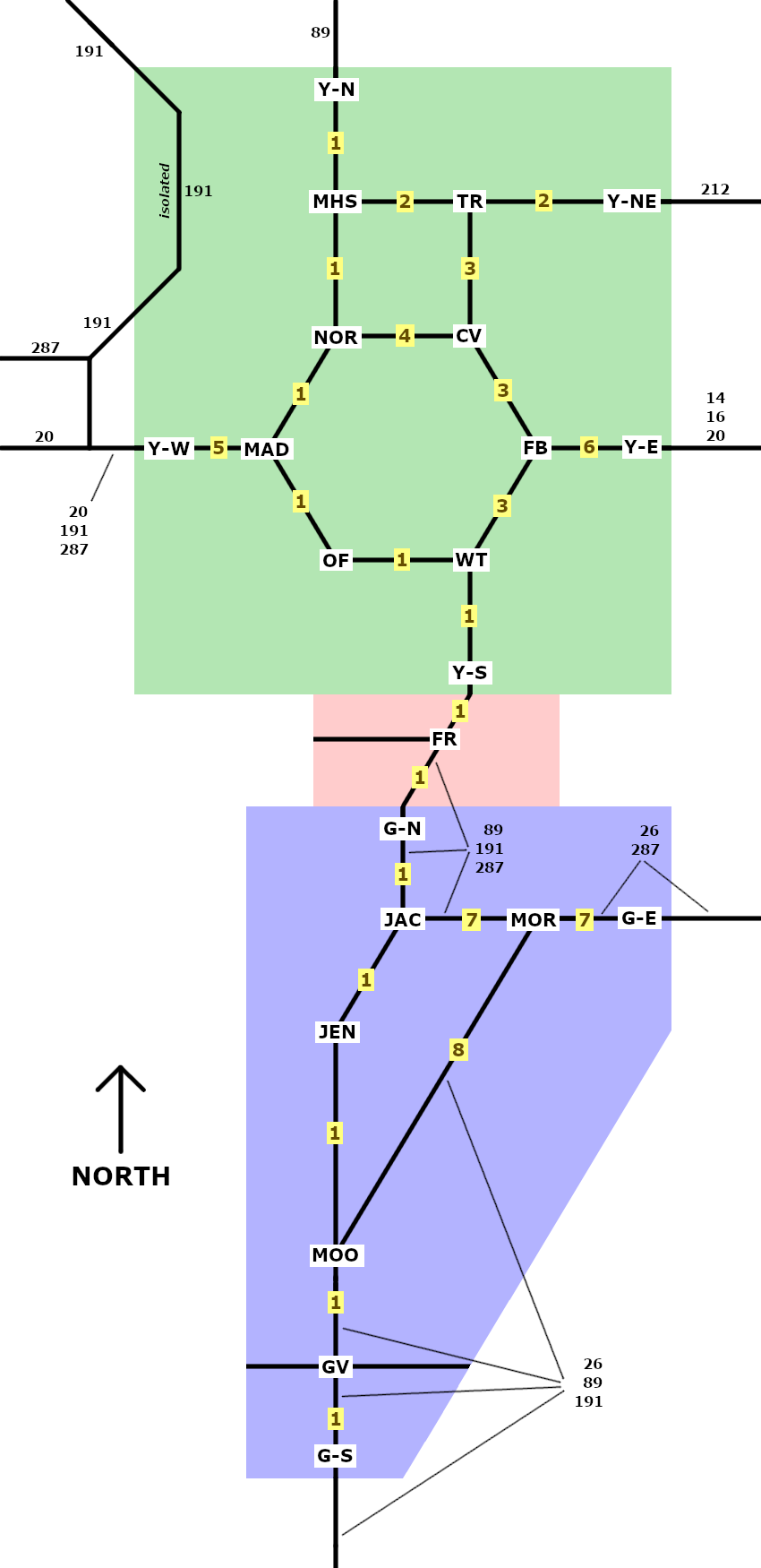
§2 Primary routes. Figure 2.1 is a diagram of the main roads of Yellowstone (green); Rockefeller (red); and Grand Teton (blue). Included are proposed numbers for the primary park routes, in brown numerals on yellow backgrounds. The other numbers indicate highways in the US numbered route system. There are no state routes (Wyoming, Montana, Idaho) nearby.
| figure 2.1 | |
|---|---|
|
Yellowstone Legend |
| Y-N = North Entrance | |
| MHS = Mammoth Hot Springs
TR = Tower-Roosevelt Y-NE = Northeast Entrance | |
| NOR = Norris Junction
CV = Canyon Village | |
| Y-W = West Entrance
MAD = Madison Junction FB = Fishing Bridge Y-E = East Entrance | |
| OF = Old Faithful
WT = West Thumb | |
| Y-S = South Entrance | |
| Rockefeller Legend | |
| FR = Flagg Ranch | |
| Grand Teton Legend | |
| G-N = North Entrance | |
| JAC = Jackson Lake Junction
MOR = Moran Junction G-E = East Entrance | |
| JEN = Jenny Lake | |
| MOO = Moose Junction | |
| GV = Gros Ventre Junction | |
| G-S = South Entrance | |
Each of these primary park routes is as close to a straight line as the mountainous terrain allows:
| north to south | PR 1 |
Y-N →
MHS →
NOR →
MAD → OF → WT → Y-S → FR → G-N → JAC → JEN → MOO → GV → G-S |
| PR 3 | TR → CV → FB → WT | |
| PR 8 | MOR → MOO | |
| west to east | PR 2 | MHS → TR → Y-NE |
| PR 4 | NOR → CV | |
| PR 5 | Y-W → MAD | |
| PR 6 | FB → Y-E | |
| PR 7 | JAC → MOR → G-E |
Yellowstone's three major loops use park routes 1 through 4:
| Upper loop 70 miles | Grand loop 142 miles | Lower loop 96 miles | |||||||||||||||||||||||||||||||||||||||||||||
|
|
|
Optional are secondary routes, with two-digit numbers; and tertiary routes which would have three digits, or two digits followed by a letter. The latter combination is also useful for camping loops.
To minimize confusion, no section of any road should carry more than one route number. Of course, not every strip of pavement needs a route number.
§3 Signage. To display these route numbers, a modest system of augmenting currently-installed signs is proposed; no current sign would be removed in whole or in part. Only a few signs would be installed in altogether new locations.
These easily-installed low-cost signs would have little environmental impact and would minimally obstruct scenic views of nature. Few individual sign panels would be larger than 30 × 24 inches; the signs would be installed at the side of the road, not overhead; and they would not be illuminated.
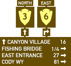
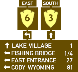
The MUTCD designates a route sign for national forests, but not national parks. Hence this report has chosen an arrowhead symbol reminiscent of the National Parks Service's logo.
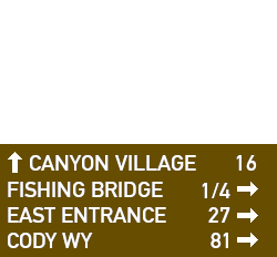
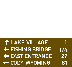
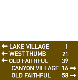
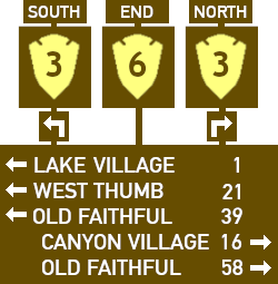
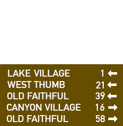
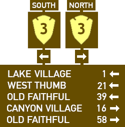
Figure 3.1 has examples of what the signs might look like at the intersection of PR 3 and PR 6, near Fishing Bridge.
|
| ||||||||||||
|
| ||||||||||||
Because of the winding and curving character of park roads, it is important that signs for primary routes include the designation of north, south, west, or east. Some secondary and tertiary routes may be so short that their direction can feasibly be omitted, for example the road that connects PR 1 to the Old Faithful area.
At each entrance to the park, drivers should see a sign informing them of the route they are on. Figure 3.2 is an example for Y-NE.
| figure 3.2 |

|
The minimal recommended set of signs has:
Other signs can be added as experience indicates. A likely choice is to install confirming signs on each road leading away from a major intersection, to inform drivers on what road they actually ended up on.
Suggested is to reserve park route numbers 9 through 19 for any future primary routes that might be developed, even though little road construction in this wilderness area is anticipated.
Precise use of bent and straight arrows to indicate turns is detailed in figure 3.3. However, many highway departments are not rigorous about this.
| figure 3.3 | turn left | turn right |
|---|---|---|
| ahead | ||
| here |
It is probably best that the route signs not bear the words "Yellowstone" or "Grand Teton". Otherwise, they might be attractive to souvenir thieves. On the other hand, the initials "NPS", for National Park Service, might be helpful to distinguish these routes from others in the vicinity, while still being at lower risk for loss.
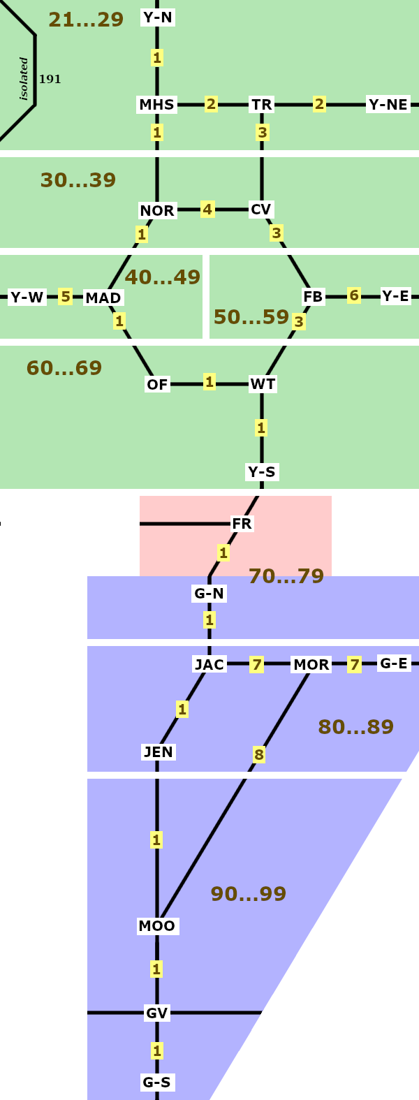
§4 Secondary routes. Route numbers 21 through 99 would designate secondary roads that are of substantial use to park visitors, perhaps assigning lower numbers in the north and higher numbers in the south. Figure 4.1 has a diagram which breaks the parks into sections, and gives a few completely arbitrary examples. The secondary roads mentioned are not shown in the diagram below, but do appear on detailed maps as linked in §1.
| figure 4.1 | |
|---|---|
| ranges | examples |
 |
PR 21: Upper Terrace Drive PR 23: Blacktail Plateau Drive PR 33: Norris Geyser Road PR 36: South Rim Drive PR 38: North Rim Drive PR 42: Madison Campground Road PR 45: Firehole Lake Drive PR 55: Lake Village Road PR 56: Gull Point Drive PR 60: Old Faithful Road PR 64: Grant Village Road PR 66: West Thumb Geyser Basin Road |
| PR 75: Headwaters Drive | |
|
PR 77: Colter Bay Village Road
PR 82: Jackson Lake Lodge Road PR 84: Signal Mountain Lodge Road PR 88: Jenny Lake Road PR 93: Antelope Flats Road PR 96: Gros Ventre Road | |
§5 Mileposts. Should route numbering be found useful, mileposts might be added along the primary routes. The combination of route number and milepost is very helpful in reporting emergencies such as automobile crashes and trees fallen across a road. It also pinpoints the location when upcoming road repairs are announced.
The MUTCD terms mileposts as reference location signs, and the MUTCD design can feasibly be employed in a park. However, it might be appropriate to use white characters on a brown background, rather than green, because these are parks.
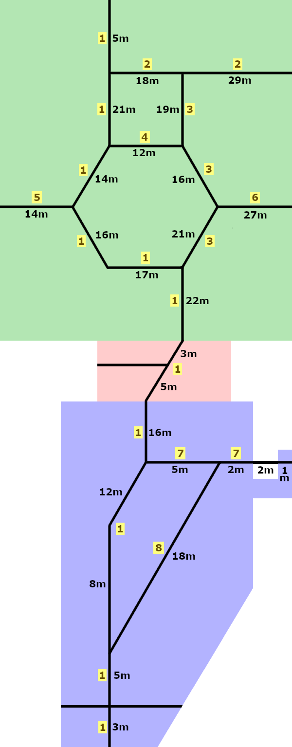
Figure 5.1a shows approximate milages between key points. Mileposts would presumably be erected at one-mile intervals, but figure 5.1b shows only a few selected values to avoid congestion in the diagram. These numbers will of course have to be adjusted when precise measurements are made.
| figure 5.1a approximate distances | figure 5.1b approximate mileposts |
| 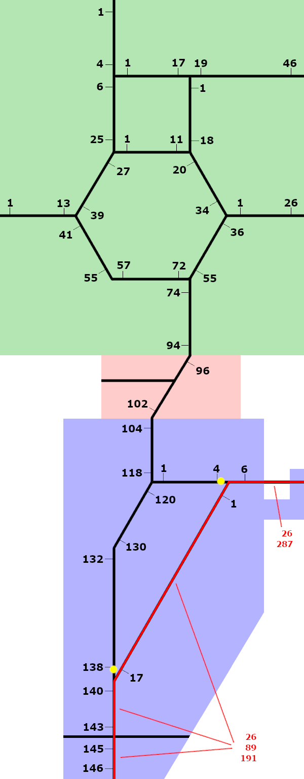
|
The section of figure 5.1b in red lies outside Grand Teton's entrance stations, and is a through route for non-park traffic. Hence it might be better served by mileposts calculated for the US routes rather than those of the park, particularly since there is an isolated section of PR 7 at the eastern entrance to Grand Teton.
The total milage of primary routes within Yellowstone is 251, and within Rockefeller 8. Establishing a total for Grand Teton is less useful because many miles of road within the park borders is outside the entrance stations (shown with yellow dots in the lower part of figure 5.1b), and can be used by through traffic for purposes unrelated to the park. The most notable section of such road, carrying US 26 and others, is shown in red.
Milages on west-east park routes are reckoned from west to east, as is the custom on highways in the United States. In this proposal, however, milages on north-south park routes are measured from the north rather than the south, going against the norm. The reason is that PR 1 has a definite and time-honored beginning point at the Roosevelt arch, which is at the northern boundary of the park. By contrast, the southern boundary of Grand Teton has no distinctive feature, in particular no entrance station nearby. Adding the considerations pertaining to through traffic mentioned in the previous paragraph, a better "mile zero" point could arguably be placed at Moose Junction. These concerns evaporate if PR 1 is measured from the northern edge of Yellowstone. In that case, other north-south park routes should also be measured from the north.
§6 Camping loops. Here is how they might be treated, using the Madison campground as an example. This area is served by a main road, and several loop roads with campsites. The loops are already lettered 'A', 'B', 'C', et cetera.
If the main road into the camping area happens to be numbered PR 42, the loops would then be signed 42A, 42B, 42C, et cetera. Each loop would keep its current letter, minimizing confusion. Signs for the camping loops could be smaller than the signs for main roads, and need not be marked as north, south, west, or east, particularly since they are short and most of them are one-way.
| figure 6.1 | ||

| 
| 
|
§7 Tertiary routes. If designated, these would have either three digits, or two digits followed by a letter. The signs, if posted, would likely be less prominent than for the primary and secondary routes. Roads not open to the public are good choices for the tertiary classification, along with very short no-outlet roads.
Figure 7.1 is the wider route sign helpful for three-digit route numbers.
| figure 7.1 |
|---|
 |
For example, if North Rim Drive is signed as PR 38, the side road for Inspiration Point might be signed as either PR 138 or PR 38A, whichever is felt to be more helpful.
Figure 7.2 shows how a park route number might be inconspicuously displayed on a non-public road.
| figure 7.2 | |
|---|---|
| currently | as proposed |

| 
|
The National Forests adjoining Yellowstone, Rockefeller, or Grand Teton are Gallatin, Custer, Shoshone, Bridger-Teton, and Caribou-Targhee.
The Forest Service assigns route numbers to many of the roads in the area, usually at least three digits with possible additional characters. Most are not signed, but it is still best if park route numbers avoid these forest route numbers where possible, as the forest route numbers do appear on maps, and could be posted in the future.
For example, Shoshone Forest lies on the east side of Yellowstone Park, and US 14-16-20 runs through it. Along the US route are many short forest routes numbered in the 400's; it would thus be best to not use these numbers in the eastern part of Yellowstone.
§8 Attempting to use the US route designations. No US route enters Yellowstone, except for the in-and-out of US 191 in the northwestern corner. Several US routes thus have gaps, for example US 20. Its western section connects Y-W with Newport OR; and its eastern section connects Y-E with Boston MA. The total length of US 20 exceeds 3000 miles, but it has a gap at Yellowstone. That gap, which is the distance from Y-W to Y-E, is about 83 driving miles via MAD, NOR, CV, and FB. A longer southern route for US 20, via MAD, OF, WT, and FB, is shown on some maps not produced by the US government; but the rationale for this routing is not evident.
US 89, US 191 (in its non-isolated section), and US 287 exhibit similar gaps. By contrast, US 14, US 16, and US 212 end at the eastern Yellowstone border, but do not continue on the other side of the park, or anywhere else. Also, US 26, which passes through Grand Teton, but not Yellowstone, has no gap. Meanwhile, US 189 is signed as far north as Jackson WY, which is only a few miles from the southern border of Grand Teton.
It difficult to adapt these US route numbers into a simple system of route markings that park visitors will find convenient. In particular, some major roads would need multiple route numbers; and other major roads would require contorted extensions of the routes. Further, the US route numbers do not lend themselves to a useful system of designating numbers for minor roads.
Another consideration is that drivers often expect low numbers for major roads, and high numbers for minor roads. The US routes provide little help here.
Figure 8.1 details the problem, displaying what may be the least contorted way to assign US route numbers to Yellowstone's main roads. Routes 20, 89, 191, and 287 take the shortest path from one park border to another. Routes 14, 16, and 212 are extended to meet other US routes.
| figure 8.1 illustrating the problem |
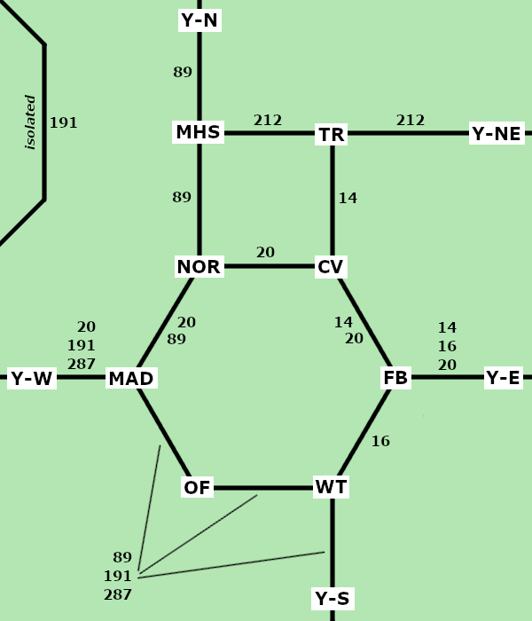
|
Overall, the best approach is still to skip these US route numbers entirely when park route numbers are being assigned.
§9 Other parks.
Should this kind of route numbering scheme be extended to other national parks? No one-size-fits-all plan can be devised, because the parks exhibit a huge variety of sizes and shapes in every sort of terrain, with widely varying numbers of visitors. In fact, some depend on non-park roads outside their borders to carry visitors from one park attraction to another. Examples:
Yellowstone differs from these in that it has a substantial network of long roads within the park. Grand Teton, considered by itself, might not merit park route designations; but with its proximity to Yellowstone, there is a strong case for using PR 1 to connect the two parks.
§10 Miscellaneous.
Yellowstone and Grand Teton parks are in a remote location:
Barring the occasional severe storm, Yellowstone roads kept open all year are the route connecting Y-N, MHS, TR, and Y-NE; and the isolated section of US 191 in the northwest part of the park. Other roads in Yellowstone are, as a rough approximation: